| River Bush | |
|---|---|
 | |
 | |
| Etymology | Old Irish búas, "stream, flow, gush" or "abounding in cattle"[1][2] |
| Native name | An Bhuais (Irish) |
| Location | |
| Sovereign State | United Kingdom |
| Constituent Country | Northern Ireland |
| Counties | Antrim |
| District | Causeway Coast and Glens |
| Cities | Bushmills, Stranocum, Armoy |
| Physical characteristics | |
| Source | |
| • location | Antrim Mountains, Northern Ireland |
| Mouth | |
• location | Portballintrae, Northern Ireland |
| Length | 54 km (34 mi) |
| Basin size | 340 km2 (130 sq mi) |
| Discharge | |
| • location | Portballintrae |
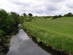
The River Bush (from the Irish: an Bhuais)[3] is a river in County Antrim, Northern Ireland. The River Bush is 33.5 miles (53.9 km) long.[4] The river's source is in the Antrim Hills at 480m. From there the river flows northwest, with a bend at the town of Armoy. It then flows west, passing through Stranocum, and then bends north, passing through Bushmills before reaching the sea at Portballintrae on the North Antrim coast. It flows through a fertile valley devoted to grassland-based agriculture with limited arable cropping. The underlying geology is basalt and the water is slightly alkaline with magnesium making an unusually large contribution to total hardness. The river supports indigenous stocks of Atlantic salmon and brown trout.[5] Saint Columb's Rill, which is a tributary of the river, is the source of water used for distilling Bushmills whiskey.
- ^ "eDIL – Irish Language Dictionary". dil.ie.
- ^ "An Bhuais/Bush River". Logainm.ie.
- ^ "Bunachar Logainmneacha na hÉireann". Logainm.ie.
- ^ Ordnance Survey of Ireland: Rivers and their Catchment Basins 1958 (Table of Reference)
- ^ "River Bush, Northern Ireland". Environmental Change Network – Freshwater Sites. Archived from the original on 25 April 2011. Retrieved 28 February 2009.