| River Dart | |
|---|---|
 | |
 | |
| Location | |
| Country | England |
| County | Devon |
| Physical characteristics | |
| Source | West Dart |
| • location | Lower White Tor |
| • elevation | 450 m (1,480 ft) |
| 2nd source | East Dart |
| • location | Kit Rock, Whinney's Down |
| • elevation | 510 m (1,670 ft) |
| Source confluence | |
| • location | Dartmeet |
| • elevation | 210 m (690 ft) |
| Mouth | English Channel |
• coordinates | 50°20′33″N 3°33′51″W / 50.34250°N 3.56417°W |
• elevation | 0 m (0 ft) |
| Length | 75 km |
| Discharge | |
| • location | Austins Bridge, Buckfastleigh |
| • average | 11.04 m3/s (390 cu ft/s) |
| • maximum | 40 m3/s (1,400 cu ft/s) |

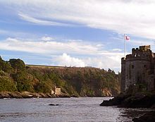
The River Dart is a river in Devon, England, that rises high on Dartmoor and flows for 75 kilometres (47 mi) to the sea at Dartmouth.[1]
- ^ "Devon;Nature Features: River Dart Ramble". BBC. Retrieved 23 January 2021.