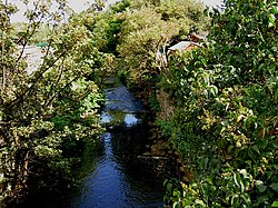
| River Dove, South Yorkshire | |
|---|---|
 River Dove on the outskirts of Darfield | |
| Location | |
| Country | England |
| Physical characteristics | |
| Source | |
| • location | Worsbrough Reservoir |
| • coordinates | 53°31′34″N 1°28′27″W / 53.52611°N 1.47417°W |
| • elevation | 56 metres (184 ft) |
| Mouth | |
• location | River Dearne nr Darfield |
• coordinates | 53°31′43″N 1°22′9″W / 53.52861°N 1.36917°W |
| Length | 4.92 miles (7.91 km) |
River Dove | ||||||||||||||||||||||||||||||||||||||||||||||||||||||||||||||||||||||||||||||||||||||||||||||||||||||||||||||||||||||||||||||||||||||||||||||||||||||||||||||||||||||||||||||||||||||
|---|---|---|---|---|---|---|---|---|---|---|---|---|---|---|---|---|---|---|---|---|---|---|---|---|---|---|---|---|---|---|---|---|---|---|---|---|---|---|---|---|---|---|---|---|---|---|---|---|---|---|---|---|---|---|---|---|---|---|---|---|---|---|---|---|---|---|---|---|---|---|---|---|---|---|---|---|---|---|---|---|---|---|---|---|---|---|---|---|---|---|---|---|---|---|---|---|---|---|---|---|---|---|---|---|---|---|---|---|---|---|---|---|---|---|---|---|---|---|---|---|---|---|---|---|---|---|---|---|---|---|---|---|---|---|---|---|---|---|---|---|---|---|---|---|---|---|---|---|---|---|---|---|---|---|---|---|---|---|---|---|---|---|---|---|---|---|---|---|---|---|---|---|---|---|---|---|---|---|---|---|---|---|
| ||||||||||||||||||||||||||||||||||||||||||||||||||||||||||||||||||||||||||||||||||||||||||||||||||||||||||||||||||||||||||||||||||||||||||||||||||||||||||||||||||||||||||||||||||||||
The River Dove is a river that extends through the Low Valley in Barnsley, England. It flows from Worsbrough Reservoir to its confluence with the River Dearne.