| Effra Brixton Creek, New River, The Wash | |
|---|---|
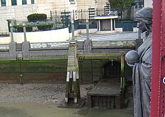
 Diverted overflow outlet of the Effra into the Thames, by Vauxhall Bridge, beneath Alfred Drury's sculpture of Science | |
 | |
| Location | |
| Country | England |
| Counties | Greater London |
| Physical characteristics | |
| Source | |
| • location | Upper Norwood Recreation Ground, Upper Norwood, London Borough of Croydon |
| • coordinates | 51°25′02″N 0°05′29″W / 51.4171°N 0.0914°W |
| Mouth | River Thames |
• location | historically Walworth Marsh; outlet now at Vauxhall |
• coordinates | 51°29′14″N 0°07′33″W / 51.4872°N 0.1257°W |
| Basin features | |
| Tributaries | |
| • right | Ambrook |
The River Effra is a former set of streams in south London, England, culverted and used mainly for storm sewerage. It had been a tributary of the Thames. Its catchment waters, where not drained to aquifer soakaways and surface water drains, have been incorporated into 1850s-built combined sewer sectors, devised by Sir Joseph Bazalgette. One drains Peckham, the other Brixton, then intended to flow towards Peckham. These generally flow east to be treated at Crossness.
When it rains these sectors can purposefully backup and overflow in two Effra sewers that mirror a known and, from the study of medieval records, a suspected distributary. At least four of these limbs can operate to enable overflow, as opposed to normal flow, and it is not known how many Southwark distributaries ran before the known diversion to Vauxhall was made in the 13th century. Overflows reach two combined sewer overflows that will discharge into the Thames Tideway Tunnel on its completion in 2025. The 13th century ending, a WNW cut – then a dyke – was dug to cut across a low plain of the strip parish of Lambeth and is emulated by a key section of the Southern Low Level Interceptor sewer.