| River Frome | |
|---|---|
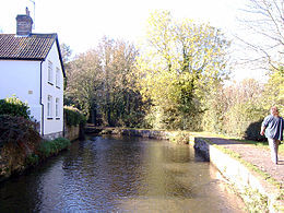
 River Frome near Dorchester | |
| Location | |
| Country | United Kingdom |
| County | Dorset |
| Physical characteristics | |
| Source | |
| • location | Evershot, Dorset |
| • coordinates | 50°50′15″N 2°36′02″W / 50.83750°N 2.60056°W |
| • elevation | 175 m (574 ft) |
| Mouth | |
• location | Poole, Dorset |
• coordinates | 50°41′45″N 1°59′19″W / 50.69583°N 1.98861°W |
| Length | 48 km (30 mi) |
| Discharge | |
| • location | East Stoke |
| • average | 6.38 m3/s (225 cu ft/s) |
| • minimum | 1.05 m3/s (37 cu ft/s)26 August 1976 |
| • maximum | 27.9 m3/s (990 cu ft/s)30 December 1993 |
| Discharge | |
| • location | Dorchester |
| • average | 3.09 m3/s (109 cu ft/s) |
| Basin features | |
| Tributaries | |
| • left | |
| • right | |
The River Frome /ˈfruːm/ is a river in Dorset in the south of England. At 30 miles (48 km) long it is the major chalkstream in southwest England. It is navigable upstream from Poole Harbour as far as the town of Wareham.
