| River Goyt | |
|---|---|
 | |
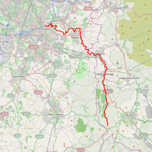
 The River Goyt is highlighted in red Coordinates: 53°24′51″N 2°09′25″W / 53.41420°N 2.15689°W | |
| Location | |
| Country | England |
| Physical characteristics | |
| Source | |
| • location | Axe Edge Moor, Derbyshire |
| • elevation | 520 m (1,710 ft)[1] |
| Mouth | |
• location | River Mersey |
• elevation | 40 m (130 ft)[2] |
| Length | 48.844 km (30.350 mi) |
| Basin features | |
| Progression | Mersey—Irish Sea |
| Tributaries | |
| • left | Todd Brook |
| • right | Sett, Etherow |
River Goyt | |||||||||||||||||||||||||||||||||||||||||||||||||||||||||||||||||||||||||||||||||||||||||||||||||||||||||||||||||||||||||||||||||||||||||||||||||||||||||||||||||||||||||||||||||||||||||||||||||||||||||||||||||||||||||
|---|---|---|---|---|---|---|---|---|---|---|---|---|---|---|---|---|---|---|---|---|---|---|---|---|---|---|---|---|---|---|---|---|---|---|---|---|---|---|---|---|---|---|---|---|---|---|---|---|---|---|---|---|---|---|---|---|---|---|---|---|---|---|---|---|---|---|---|---|---|---|---|---|---|---|---|---|---|---|---|---|---|---|---|---|---|---|---|---|---|---|---|---|---|---|---|---|---|---|---|---|---|---|---|---|---|---|---|---|---|---|---|---|---|---|---|---|---|---|---|---|---|---|---|---|---|---|---|---|---|---|---|---|---|---|---|---|---|---|---|---|---|---|---|---|---|---|---|---|---|---|---|---|---|---|---|---|---|---|---|---|---|---|---|---|---|---|---|---|---|---|---|---|---|---|---|---|---|---|---|---|---|---|---|---|---|---|---|---|---|---|---|---|---|---|---|---|---|---|---|---|---|---|---|---|---|---|---|---|---|---|---|---|---|---|---|---|---|
| |||||||||||||||||||||||||||||||||||||||||||||||||||||||||||||||||||||||||||||||||||||||||||||||||||||||||||||||||||||||||||||||||||||||||||||||||||||||||||||||||||||||||||||||||||||||||||||||||||||||||||||||||||||||||
The River Goyt is a tributary of the River Mersey in North West England.
- ^ Environment Agency (March 2004). "The Tame, Goyt and Etherow catchment abstraction management strategy". Environment Agency North West, Warrington. p. 6. Archived from the original (pdf) on 27 September 2007. Retrieved 13 March 2007.
- ^ Boyce, D (August 2005). "Mersey and Bollin Catchment abstraction management strategy". Environment Agency North West, Warrington. p. 5. Archived from the original (pdf) on 27 September 2007. Retrieved 13 March 2007.