| River Kyle | |
|---|---|
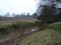
 Footbridge over River Kyle at Alne 54°4′41.41″N 1°14′28.56″W / 54.0781694°N 1.2412667°W | |
 | |
| Location | |
| Country | England |
| Physical characteristics | |
| Source | |
| • location | Confluence of Derrings Beck and Carle Beck nr Tholthorpe |
| • coordinates | 54°5′24″N 1°15′38″W / 54.09000°N 1.26056°W |
| • elevation | 12 metres (39 ft) |
| Mouth | |
• location | River Ouse nr Newton-on-Ouse |
• coordinates | 54°2′5″N 1°13′28″W / 54.03472°N 1.22444°W |
• elevation | 11 metres (36 ft) |
| Length | 9.3 kilometres (5.8 mi) |
The River Kyle is a small river in North Yorkshire, England. At just under 6 miles (9.7 km) long, it is one of the shortest classified main rivers in the country.