| River Lee | |
|---|---|
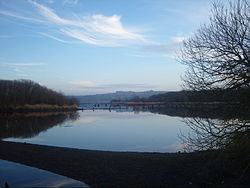
 The Gearagh, a submerged woodland situated on the Lee near Macroom | |
 Map of the River Lee drainage basin | |
| Native name | An Laoi (Irish) |
| Physical characteristics | |
| Source | |
| • location | Shehy Mountains near Gougane Barra |
| Mouth | |
• location | Celtic Sea at Cork Harbour mouth |
| Length | 90 km (56 mi)[1] |
| Basin size | 1,253.5 km2 (484.0 sq mi)[1] |
| Discharge | |
| • average | 40.4 m3/s (1,430 cu ft/s)[2] |
| Basin features | |
| Tributaries | |
| • right | Curraheen River |
The River Lee (Irish: An Laoi[3]) is a river in Ireland. It rises in the Shehy Mountains on the western border of County Cork and flows eastwards through Cork, where it splits in two for a short distance, creating an island on which Cork's city centre is built, then passing through Cork Harbour on the south coast, one of the largest natural harbours in the world, to empty into the Celtic Sea. The catchment area of the River Lee is 1,253 km2.[4] The long-term average flow rate of the River Lee is 40.4 cubic metres per second (m3/s)[4]
A hydro-electric scheme was built on the river, upstream from Cork City, and this part of the river now contains the Carrigadrohid and Inniscarra reservoirs. The river is crossed by 42 bridges, 29 of which are in Cork City, and one tunnel. The river also provides an 8 kilometres (5.0 mi) stretch of salmon fishing.[citation needed]
- ^ a b "Irishfisheries.com/waterways - River Lee". irishfisheries.com. Archived from the original on 17 November 2007.
- ^ "Archived copy" (PDF). Archived from the original (PDF) on 3 March 2016. Retrieved 2 March 2015.
{{cite web}}: CS1 maint: archived copy as title (link) - ^ "An Laoi/River Lee". Logainm.ie. Irish Placenames Commission. Retrieved 17 December 2019.
- ^ a b South Eastern River Basin District Management System (PDF). South Eastern River Basin District Report (Report). p. 38. Archived from the original (PDF) on 3 March 2016.