| River Otter | |
|---|---|
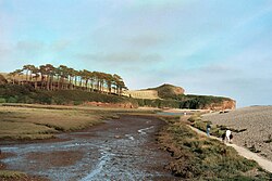
 The tidal estuary of the Otter. The river flows left to right, in front of the distinctive hill. The marsh (foreground) is separated from the sea by a steep pebble bar (right). | |
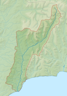
 Map of the River Otter and its catchment. | |
| Location | |
| Country | England |
| Counties | Somerset, Devon |
| Physical characteristics | |
| Source | |
| • location | Blackdown Hills, Somerset, England |
| • elevation | 275 m (902 ft)[1] |
| Mouth | |
• location | Budleigh Salterton, Devon, England |
• elevation | 0 m (0 ft) |
| Length | 44 km (27 mi)[2] |
| Discharge | |
| • location | Dotton |
| • average | 3.12 m3/s (110 cu ft/s) |
| • minimum | 0.46 m3/s (16 cu ft/s)(24 August 1976) |
| • maximum | 346.7 m3/s (12,240 cu ft/s)(11 July 1968) |
| Discharge | |
| • location | Fenny Bridges |
| • average | 2.13 m3/s (75 cu ft/s) |
| Basin features | |
| Tributaries | |
| • right | River Tale[1] |
The River Otter is a river that rises in the Blackdown Hills just inside the county of Somerset, England near Otterford, then flows south through East Devon.[3] It enters the English Channel at the western end of Lyme Bay, part of the Jurassic Coast, a UNESCO World Heritage Site. The Permian and Triassic sandstone aquifer in the Otter Valley is one of Devon's largest groundwater sources, supplying drinking water to 200,000 people.
- ^ a b Knott, Eleanor. "River Otter catchment overview" (PDF). Devon Biodiversity Records Centre/University of Exeter. Retrieved 1 June 2020.
- ^ "Enhancing The River Otter". Agricultural & Environmental Data Archive. Environment Agency. Retrieved 2 June 2020.
- ^ Sinclair, Archibald (1843). A system of modern geography. Shields & Son. p. 267.