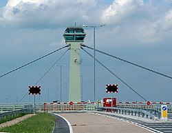
River Ouse swing bridge | |
|---|---|
 Selby, A63 Swing Bridge control Tower | |
| Coordinates | 53°46′37″N 1°02′13″W / 53.777°N 1.037°W |
| OS grid reference | SE615316 |
| Carries | A63 road |
| Crosses | River Ouse |
| Locale | Selby, North Yorkshire, England |
| Preceded by | Selby swing bridge |
| Followed by | Boothferry Bridge |
| Characteristics | |
| Total length | 95.2 metres (312 ft) |
| Width | 17.96 metres (58.9 ft) |
| Clearance below | 3.85 metres (12.6 ft) |
| History | |
| Designer | High Point Rendel |
| Constructed by | Skanska |
| Opened | June 2004 |
| Location | |
 | |
The River Ouse swing bridge is a road bridge over the River Ouse in North Yorkshire, England. It was opened in 2004 when the A63 road bypassed the town of Selby, which traffic previously had to go through to cross the river. It is one of several bridges over the River Ouse between York and the mouth of the Ouse, where it joins the River Trent.