| River Rwizi | |
|---|---|
 Waste in River Rwizi | |
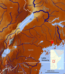
 Rivers in South West Uganda with the Ruizi (lower left center). | |
| Location | |
| Country | Uganda |
| Physical characteristics | |
| Source | Buhweju hills |
| Mouth | |
• location | To Lake Victoria via the drainage systems of Lake Mburo, Lake Kachera and Kijanebalola. |
• coordinates | 0°41′33″S 30°54′20″E / 0.69250°S 30.90556°E |
• elevation | 1,258 m (4,127 ft) |
| Basin size | 2,282 km2 (881 sq mi)[1] |
| Discharge | |
| • location | Mbarara[2] |
| • average | 25.4 m3/s (900 cu ft/s) |
| • minimum | 16.5 m3/s (580 cu ft/s) |
| • maximum | 35.7 m3/s (1,260 cu ft/s) |
| Basin features | |
| Progression | Lake Victoria—White Nile—Nile—Mediterranean Sea |
| River system | Nile basin |
River Rwizi is a river located in South Western Uganda in district called Mbarara. River Rwizi is a river located in southwestern Uganda. It is the second-longest river in Uganda, after the Nile River. The river originates in the hills of Buhweju District and flows through the districts of Sheema, Bushenyi, Ntungamo, Rwampara, Mbarara, Isingiro, Kiruhura, Lyantonde, Rakai, and Kyotera. It eventually empties into Lake Victoria.[3] Many swamps feed river Rwizi, including Nyakafumura, part of the Mushasha water basin, and Kanyabukanja wetland. These marshes function as water reservoirs or catchments, gently releasing water into the river to support the surrounding population.[4][5][6][7][8][9]
- ^ Basooma, Anthony; Teunen, Lies; Semwanga, Nathan; Bervoets, Lieven (2021). "Trace metal concentrations in the abiotic and biotic components of River Rwizi ecosystem in western Uganda, and the risks to human health". Heliyon. 7 (11): e08327. Bibcode:2021Heliy...708327B. doi:10.1016/j.heliyon.2021.e08327. PMC 8593446. PMID 34816035.
- ^ Vörösmarty, Charles J.; Fekete, B. M.; Tucker, B. A. (2004). "Monthly mean river discharge at gauging station Mbarara Water Supply". Pangaea. doi:10.1594/PANGAEA.218872.
{{cite journal}}: Cite journal requires|journal=(help) - ^ Mugira, Fredrick (2019-08-29). "Road River: The story of a river dried by illegal land acquisitions | Earth Journalism Network". earthjournalism.net. Retrieved 2023-06-19.
- ^ "River Rwizi on the verge of drying up". landportal.org. 2021-09-28. Retrieved 2023-06-19.
- ^ "How River Rwizi destruction has left Mbarara in a mess". Monitor. 2021-01-05. Retrieved 2023-06-19.
- ^ Cite error: The named reference
:3was invoked but never defined (see the help page). - ^ "Road River: A Photo Story of a River Dried by Illegal Land Acquisitions". Pulitzer Center. Retrieved 2023-06-19.
- ^ Africa, Water Journalists (2019-08-20). "Road River: A photo story of a river dried by illegal land acquisitions". Water Journalists Africa. Retrieved 2023-06-19.
- ^ MATSIKO, PATRICK (2021-09-08). "Why Rwizi, Ankole's biggest river is drying up". The Observer - Uganda. Retrieved 2023-06-19.