| River Tame | |
|---|---|
 The Tame at Tamworth, which takes its name from the river. | |
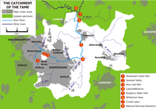
 Sketchmap of the course and catchment of the River Tame, showing locations of some features mentioned in the text | |
| Location | |
| Country | England |
| Counties | West Midlands, Warwickshire, Staffordshire |
| Cities | Wolverhampton, Birmingham |
| Towns | Oldbury, West Midlands, Tipton, Wednesbury, Willenhall, Walsall, Tamworth |
| Physical characteristics | |
| Source | Oldbury Arm |
| • location | Titford, Oldbury |
| • coordinates | 52°29′11″N 2°01′25″W / 52.4863°N 2.0235°W |
| 2nd source | Willenhall Arm |
| • location | Willenhall, Walsall |
| • coordinates | 52°34′32″N 2°05′32″W / 52.5756°N 2.0922°W |
| Mouth | Confluence with the River Trent |
• location | Alrewas, Staffordshire |
• coordinates | 52°43′52″N 1°43′02″W / 52.7312°N 1.7173°W |
| Length | 95 km (59 mi)[1] |
| Basin size | 1,500 km2 (580 sq mi)[1] |
| Discharge | |
| • location | Hopwas[2] |
| • average | 27.84 m3/s (983 cu ft/s) |
| • maximum | 435 m3/s (15,400 cu ft/s)[3] |
| Basin features | |
| Progression | Tame → Trent → Humber → North Sea |
| Tributaries | |
| • left | Ford Brook, Full brook, Sneyd Brook, Plants Brook, Bourne Brook |
| • right | Darlaston Brook, Rea, Blythe, Bourne, Anker |
 | |
The River Tame is a river in the West Midlands of England, and one of the principal tributaries of the River Trent.[4] The Tame is about 95 km (59 mi) long from the source at Oldbury to its confluence with the Trent near Alrewas,[1] but the main river length of the entire catchment, i.e. the Tame and its main tributaries, is about 285 km (177 mi).
It forms part of the Severn-Trent flyway, a route used by migratory birds to cross Great Britain.[5]
- ^ a b c "WFD Surface Water Classification Status and Objectives 2012 csv files". Environment-agency.gov.uk. Archived from the original on 24 February 2014. Retrieved 7 April 2013.
- ^ "28095-Tame at Hopwas Bridge". The National River Flow Archive. Centre for Ecology & Hydrology. Retrieved 20 April 2013.
- ^ "Hi Flows UK – Tame at Hopwas Bridge". Environment-agency.gov.uk. Retrieved 20 April 2013.
- ^ Environment Agency, River Tame flood risk management scoping report – 2: The Tame Catchment, 2004, p. 3,
- ^ RSPB Where To Go Wild in Britain. Dorling Kindersley. 2009. p. 265. ISBN 978-1405335126.