| Tud | |
|---|---|
 | |
| Location | |
| Country | England |
| Region | Norfolk |
| Physical characteristics | |
| Source | |
| • location | north of Shipdham |
| • coordinates | 52°38′35″N 0°54′35″E / 52.6430°N 0.9097°E |
| • elevation | 76 m (249 ft) |
| Mouth | River Wensum |
• location | Hellesdon |
• coordinates | 52°38′47″N 1°14′55″E / 52.6464°N 1.2486°E |
• elevation | 4 m (13 ft) |
| Length | 27.0 km (16.8 mi) |
| Basin features | |
| River system | River Wensum |
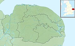
River Tud is a tributary of the River Wensum, Norfolk in the East of England. The Tud's source is just south of East Dereham and it flows in an easterly direction for 27 kilometres (17 mi) to its confluence with the Wensum below Hellesdon mill. According to a 2024 citizen science project,[1] the Tud should be classified as a chalk stream.
- ^ "Citizen scientists claim chalk stream find on road route". Eastern Daily Press. 2024-09-16.
