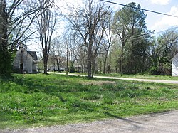
Rives, Tennessee | |
|---|---|
 Streetside at the site of Dickey's Octagonal Barbershop | |
 Location of Rives in Obion County, Tennessee. | |
| Coordinates: 36°21′26″N 89°2′59″W / 36.35722°N 89.04972°W | |
| Country | United States |
| State | Tennessee |
| County | Obion |
| Government | |
| • Mayor | Lester Burnes |
| Area | |
| • Total | 0.34 sq mi (0.89 km2) |
| • Land | 0.34 sq mi (0.89 km2) |
| • Water | 0.00 sq mi (0.00 km2) |
| Elevation | 299 ft (91 m) |
| Population | |
| • Total | 246 |
| • Density | 713.04/sq mi (275.11/km2) |
| Time zone | UTC-6 (Central (CST)) |
| • Summer (DST) | UTC-5 (CDT) |
| ZIP code | 38253 |
| Area code | 731 |
| FIPS code | 47-63800[4] |
| GNIS feature ID | 1299539[2] |
Rives is a town in Obion County, Tennessee. The population was 312 at the 2020 census. It is part of the Union City, TN–KY Micropolitan Statistical Area.
Located just south of Union City, Rives was originally known as Troy Station. Settlers from South Carolina first came to the area in the 1820's and by the 1850's the town was flourishing because of the Mobile and Ohio Railroad. Rives has a rich railroad history and at one time the town had several hotels to serve the passenger trains that traveled the area.[5]
- ^ "ArcGIS REST Services Directory". United States Census Bureau. Retrieved October 15, 2022.
- ^ a b U.S. Geological Survey Geographic Names Information System: Rives, Tennessee
- ^ Cite error: The named reference
USCensusDecennial2020CenPopScriptOnlywas invoked but never defined (see the help page). - ^ "U.S. Census website". United States Census Bureau. Retrieved January 31, 2008.
- ^ "Rives, TN | Town Information".