| Rivington | |
|---|---|
 Rivington Pike, from Georges Lane | |
Location within Lancashire | |
| Area | 3.97 sq mi (10.3 km2) |
| Population | 109 (2011 Census) |
| • Density | 27/sq mi (10/km2) |
| OS grid reference | SD626144 |
| Civil parish |
|
| District | |
| Shire county | |
| Region | |
| Country | England |
| Sovereign state | United Kingdom |
| Post town | BOLTON |
| Postcode district | BL6 |
| Dialling code | 01204 |
| Police | Lancashire |
| Fire | Lancashire |
| Ambulance | North West |
| UK Parliament | |
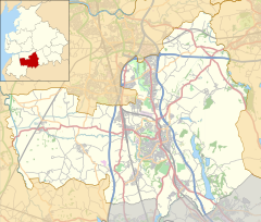
Rivington is a village and civil parish of the Borough of Chorley, Lancashire, England, occupying 2,538 acres (4.0 sq mi; 10.3 km2). It is about 6 miles (9.7 km) southeast of Chorley and about 8+1⁄2 miles (13.7 km) northwest of Bolton.[1] Rivington is a rural area consisting primarily of agricultural grazing land, moorland, with hill summits including Rivington Pike and Winter Hill within the West Pennine Moors. The area has a thriving tourist industry centred around reservoirs created to serve Liverpool in the Victorian era and Lever Park created as a public park by William Lever at the turn of the 20th century, with two converted barns, a replica of Liverpool Castle and open countryside. Rivington and Blackrod High School is located here. Rivington and its village had a population of 109 at the 2011 Census.[2][3]
- ^ Rivington Township Boundaries. GenUKI. Retrieved 6 June 2010.
- ^ Cite error: The named reference
rivingtonkeystatistics2011was invoked but never defined (see the help page). - ^ "West Pennine Moors Management Plan 2010-2020" (PDF). Blackburn Council. Blackburn and Darwen District Council. Retrieved 23 June 2019.

