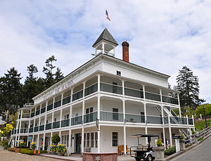
Roche Harbor | |
|---|---|
 Hotel de Haro | |
| Coordinates: 48°36′35″N 123°08′56″W / 48.60972°N 123.14889°W | |
| Country | United States |
| State | Washington |
| County | San Juan |
| Population (2020) | |
| • Total | 651[1] |
| Time zone | UTC-8 (Pacific (PST)) |
| • Summer (DST) | UTC-7 (PDT) |
| ZIP code | 98250[2] |
| Area code | 360 |
Roche Harbor | |
| Location | Northern San Juan Island, San Juan Island, Washington |
| Area | 140 acres (57 ha) |
| Built | 1886 |
| NRHP reference No. | 77001356[3] |
| Added to NRHP | August 29, 1977 |
Roche Harbor is a sheltered harbor on the northwest side of San Juan Island in San Juan County, Washington, United States, and the site of a resort of the same name. Roche Harbor faces Haro Strait and the Canada–United States border. The harbor itself provides one of the better protected anchorages in the islands. The harbor is surrounded on the east side by San Juan Island, on the north side by Pearl Island, and on the west and south sides by Henry Island. Most of the harbor is 35 to 45 feet (11 to 14 meters) deep. Roche Harbor has a small airport used primarily by local residents.
Roche Harbor is a designated U.S. port of entry. A Customs dock occupies a section of the marina, with Customs and Border Protection agents on duty during summer months. When agents are not on duty, arriving boaters must call Customs and Border Protection from the Customs Dock.[4]
- ^ "Roche Harbor WA Population 2021". zipdatamaps.com. 2023. Retrieved June 16, 2023.
- ^ "Roche Harbor WA ZIP Code". zipdatamaps.com. 2023. Retrieved June 16, 2023.
- ^ "National Register Information System". National Register of Historic Places. National Park Service. July 9, 2010.
- ^ "Pleasure Boat Ports of Entry in Washington".

