Rock Island County | |
|---|---|
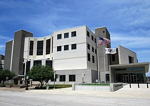
 Rock Island County Justice Center | |
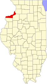
 Location within the U.S. state of Illinois | |
 Illinois's location within the U.S. | |
| Coordinates: 41°28′N 90°34′W / 41.47°N 90.57°W | |
| Country | |
| State | |
| Founded | 1831 |
| Named for | Rock (Arsenal) Island |
| Seat | Rock Island |
| Largest city | Moline |
| Area | |
• Total | 451 sq mi (1,170 km2) |
| • Land | 428 sq mi (1,110 km2) |
| • Water | 24 sq mi (60 km2) 5.2% |
| Population (2020) | |
• Total | 144,672 |
• Estimate (2023) | 141,236 |
| • Density | 320/sq mi (120/km2) |
| Time zone | UTC−6 (Central) |
| • Summer (DST) | UTC−5 (CDT) |
| Congressional district | 17th |
| Website | rockislandcountyil |
Rock Island County is a county located in the U.S. state of Illinois, bounded on the west by the Mississippi River. According to the 2020 census, it had a population of 144,672.[1] Its county seat is Rock Island; its largest city is neighboring Moline.[2] Rock Island County is one of the four counties that make up the Davenport-Moline-Rock Island, IA-IL Metropolitan Statistical Area.[3]
- ^ "Rock Island County, Illinois". United States Census Bureau. Retrieved June 10, 2023.
- ^ "Find a County". National Association of Counties. Archived from the original on May 31, 2011. Retrieved June 7, 2011.
- ^ United States Office of Management and Budget. "Update of Statistical Area Definitions and Guidance on Their Uses" (PDF). pp. 5, 36. Archived from the original (PDF) on May 14, 2006. Retrieved July 21, 2006.