| Rockfish Gap | |
|---|---|
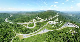
 Aerial view of Rockfish Gap showing the junction of I-64, US-250 and Blue Ridge Parkway. | |
| Elevation | 1,903 ft (580 m)[1] |
| Traversed by | |
| Location | Border of Augusta and Nelson counties, Virginia, United States |
| Range | Blue Ridge Mountains |
| Coordinates | 38°01′57″N 78°51′29″W / 38.0324°N 78.8580°W |
| Topo map | Waynesboro East |
Rockfish Gap is a wind gap located in the Blue Ridge Mountains between Charlottesville and Waynesboro, Virginia, United States, through Afton Mountain, which is frequently used to refer to the gap.
Joining the Shenandoah Valley to the Piedmont region of the state, it is the site of the mountain crossing of Interstate 64, U.S. Route 250, and the former Blue Ridge Railroad which later became part of the Chesapeake and Ohio Railway and is currently part of the CSX line. With an elevation of about 1,900 feet (580 m), it is one of the lowest gaps between Manassas Gap and the James River. Rockfish Gap lies along a drainage divide between southeast-flowing streams that drain to the James River and northwest-flowing streams in the Shenandoah River system.
The scenic Skyline Drive, which runs north through Shenandoah National Park to Front Royal, and the Blue Ridge Parkway, which runs south to a point near Cherokee, North Carolina, each generally following the mountain ridgetops, meet a short distance north of Rockfish Gap (such that the roadway on the bridge over the gap is actually part of the Blue Ridge Parkway). The Appalachian Trail also passes through the gap.
