Rockford | |
|---|---|
 Rockford's Main Street, with city hall on the left | |
 | |
| Coordinates: 45°5′26″N 93°44′20″W / 45.09056°N 93.73889°W | |
| Country | United States |
| State | Minnesota |
| Counties | Wright, Hennepin |
| Government | |
| • Mayor | Renee Hafften [1] |
| Area | |
• Total | 2.60 sq mi (6.73 km2) |
| • Land | 2.53 sq mi (6.54 km2) |
| • Water | 0.07 sq mi (0.18 km2) |
| Elevation | 915 ft (279 m) |
| Population (2020) | |
• Total | 4,500 |
| • Density | 1,781.47/sq mi (687.79/km2) |
| Time zone | UTC-6 (Central (CST)) |
| • Summer (DST) | UTC-5 (CDT) |
| ZIP code | 55373 |
| Area code | 763 |
| FIPS code | 27-55006[3] |
| GNIS feature ID | 0650206[4] |
| Website | www.cityofrockford.org |
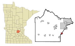
Rockford is a city in Wright and Hennepin counties in the U.S. state of Minnesota. The population was 4,316 at the 2010 census.[5] While Rockford is mainly located within Wright County, a small part of the city extends into Hennepin County. It is part of the Minneapolis–Saint Paul metropolitan statistical area. Minnesota State Highway 55 serves as a main route in the city.
- ^ "City Council".
- ^ "2020 U.S. Gazetteer Files". United States Census Bureau. Retrieved July 24, 2022.
- ^ "U.S. Census website". United States Census Bureau. Retrieved January 31, 2008.
- ^ "US Board on Geographic Names". United States Geological Survey. October 25, 2007. Retrieved January 31, 2008.
- ^ "2010 Census Redistricting Data (Public Law 94-171) Summary File". American FactFinder. U.S. Census Bureau, 2010 Census. Retrieved April 23, 2011.[dead link]