Rockwall County | |
|---|---|
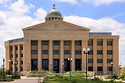
 The Rockwall County Courthouse in Rockwall | |
 Location within the U.S. state of Texas | |
 Texas's location within the U.S. | |
| Coordinates: 32°53′N 96°25′W / 32.89°N 96.41°W | |
| Country | |
| State | |
| Founded | 1873 |
| Named for | Rockwall, Texas, named in turn for its clastic dikes |
| Seat | Rockwall |
| Largest city | Rockwall |
| Area | |
• Total | 149 sq mi (390 km2) |
| • Land | 127 sq mi (330 km2) |
| • Water | 22 sq mi (60 km2) 15% |
| Population (2020) | |
• Total | 107,819 |
| • Density | 720/sq mi (280/km2) |
| Demonym | Rockwallian |
| Time zone | UTC−6 (Central) |
| • Summer (DST) | UTC−5 (CDT) |
| Congressional district | 4th |
| Website | www |
Rockwall County is a county in the U.S. state of Texas. At 149 square miles (390 sq km), Rockwall County has the smallest area of any Texas county. Per the 2020 Census, its population was 107,819.[1] Its county seat is Rockwall.[2] The county and city are named for a wall-like subterranean rock formation that runs throughout the county.
Rockwall County is part of the Dallas-Fort Worth-Arlington metropolitan statistical area. It was one of the top 25 fastest-growing counties in the U.S. in 2010.[3] Rockwall County is listed as the wealthiest county in Texas and the 17th wealthiest in the United States by median household income.
Cities in Rockwall County include Rockwall, Heath, Royse City, Fate, McClendon-Chisholm, Mobile City, and part of Rowlett.
- ^ "Rockwall County, Texas". United States Census Bureau. Retrieved January 30, 2022.
- ^ "Find a County". National Association of Counties. Retrieved June 7, 2011.
- ^ El Naser, Haya (March 23, 2010). "Texas big Census winner this decade". USA Today. Retrieved January 21, 2020.