| Rocky River | |
|---|---|
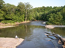
 A shale cliff along the Rocky River in the Cleveland Metroparks Rocky River Reservation, located on the boundary of the cities of Lakewood and Rocky River, Ohio. | |
 | |
| Location | |
| Country | United States of America |
| Physical characteristics | |
| Source | |
| • location | Confluence of East Branch Rocky River and West Branch Rocky River, between Cleveland and North Olmsted, Cuyahoga County, Ohio |
| • coordinates | 41°24′23″N 81°53′14″W / 41.40639°N 81.88722°W |
| • elevation | 657 feet (200 m) AMSL |
| Mouth | |
• location | Lake Erie between Lakewood and Rocky River, Cuyahoga County, Ohio |
• coordinates | 41°29′28″N 81°50′21″W / 41.49111°N 81.83917°W |
• elevation | 571 feet (174 m) AMSL |
| Basin features | |
| GNIS ID | 1066928 |


The Rocky River is a relatively short river in Cuyahoga County, Ohio that forms the natural western boundaries of Cleveland and the suburb of Lakewood with the suburbs of Fairview Park and Rocky River. The latter community is named after the river. To the south of Fairview Park and west of Cleveland Hopkins International Airport, the river forms the natural boundary between the suburb of Brook Park and the communities of North Olmsted and Olmsted Township. Ranked by Field & Stream as one of the top steelhead trout rivers in the world, the Rocky River is the center of the Rocky River Reservation of the Cleveland Metroparks.