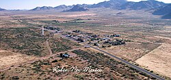
Rodeo, New Mexico | |
|---|---|
 | |
| Coordinates: 31°50′23″N 109°01′36″W / 31.83972°N 109.02667°W[1] | |
| Country | United States |
| State | New Mexico |
| County | Hidalgo |
| Area | |
• Total | 8.19 sq mi (21.22 km2) |
| • Land | 8.19 sq mi (21.22 km2) |
| • Water | 0.00 sq mi (0.00 km2) |
| Elevation | 4,124 ft (1,257 m) |
| Population | |
• Total | 108 |
| • Density | 13.18/sq mi (5.09/km2) |
| ZIP Code | 88056 |
| Area code | 575 |
| FIPS code | 35-64370 |
| GNIS feature ID | 2584194[1] |
| Website | www |
Rodeo is a census-designated place (CDP) in Hidalgo County, New Mexico, United States.[1] It lies less than one mile (1.6 km) from the border with Arizona on New Mexico State Road 80. As of the 2010 census, the population of Rodeo was 101.[4]
- ^ a b c d U.S. Geological Survey Geographic Names Information System: Rodeo, New Mexico
- ^ "ArcGIS REST Services Directory". United States Census Bureau. Retrieved October 12, 2022.
- ^ Cite error: The named reference
USCensusDecennial2020CenPopScriptOnlywas invoked but never defined (see the help page). - ^ "Geographic Identifiers: 2010 Census Summary File 1 (G001): Rodeo CDP, New Mexico". American Factfinder. U.S. Census Bureau. Archived from the original on February 13, 2020. Retrieved August 25, 2017.

