Rohtas District | |
|---|---|
 | |
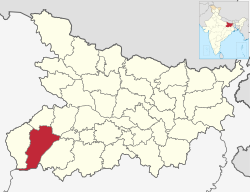
 Location of Rohtas district in Bihar | |
| Country | |
| State | |
| Division | Patna |
| Headquarters | Sasaram |
| Government | |
| • Lok Sabha constituencies | Sasaram, Karakat, Buxar |
| • District Magistrate | Udita Singh, Indian Administrative Service |
| • Superintendent of Police | Roshan Kumar, Indian Police Service |
| • Divisional Forest Officer | Manish Kumar Verma, Indian Forest Service |
| Area | |
• Total | 3,847.82 km2 (1,485.65 sq mi) |
| Population (2011) | |
• Total | 2,959,918 |
| • Density | 770/km2 (2,000/sq mi) |
| Demographics | |
| • Literacy | 73.37% |
| • Sex ratio | 914 |
| Languages | |
| • Official | |
| Time zone | UTC+05:30 (IST) |
| PIN | 821311 (Rohtas)[2] |
| ISO 3166 code | 06188 |
| Vehicle registration | BR 24 |
| Major highways | NH 2 |
| Website | Official District Website |

Rohtas District is one of the thirty-eight districts of Bihar state, India. It came into existence when Shahabad District was bifurcated into Bhojpur & Rohtas in 1972. Administrative headquarter of the district is Sasaram.[3] Rohtas district has the highest literacy in Bihar. The literacy rate of Rohtas district which is 73.37% as per 2011 census is highest among all 38 districts of Bihar.
Rohtas district also has one of the highest forest cover among all 38 districts of Bihar.[citation needed]
The Rohtas district is a part of Patna Division, and it has an area of 3850 km², a population of 2,959,918 (2011 census), and a population density of 763 persons per km². Languages spoken here are Bhojpuri, Hindi and English.[3]
- ^ a b "52nd Report of the Commissioner for Linguistic Minorities in India" (PDF). nclm.nic.in. Ministry of Minority Affairs. Archived from the original (PDF) on 25 May 2017. Retrieved 9 August 2020.
- ^ Rohtas
- ^ a b "District Rohtas, Government of Bihar | Rice bowl of Bihar | India". Retrieved 1 May 2020.