| Rollins Pass | |
|---|---|
| Boulder Pass, Corona Pass, Rollinsville Pass | |
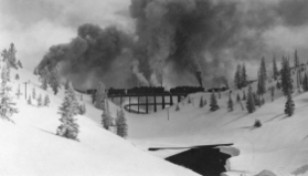
 The Riflesight Notch trestle on Rollins Pass | |
| Elevation | 11,676.79 ft (3,559 m)[1] |
| Traversed by |
|
| Location | Boulder, Gilpin, and Grand counties, Colorado, U.S. |
| Range | Front Range |
| Coordinates | 39°56′03″N 105°40′58″W / 39.93417°N 105.68278°W[1] |
| Topo map | USGS East Portal |
Rollinsville and Middle Park Wagon Road / Denver, Northwestern and Pacific Railway Hill Route Historic District | |
| Area | 436.3 acres (176.6 ha) |
| Built | 1873 |
| Built by | Rollins, John Q.A. |
| NRHP reference No. | 80000881, 97001114[8] |
| Added to NRHP | Tuesday, September 30, 1980 |
Rollins Pass, elevation 11,676 ft (3,559 m), is a mountain pass and active archaeological site[9][10][2] in the Southern Rocky Mountains of north-central Colorado in the United States. The pass is located on and traverses the Continental Divide of the Americas at the crest of the Front Range southwest of Boulder and is located approximately five miles east and opposite the resort in Winter Park—in the general area between Winter Park and Rollinsville. Rollins Pass is at the boundaries of Boulder, Gilpin, and Grand counties. Over the past 10,000 years,[9] the pass provided a route over the Continental Divide between the Atlantic Ocean watershed of South Boulder Creek (in the basin of the South Platte River) with the Pacific Ocean watershed of the Fraser River, a tributary of the Colorado River.
The abandoned rail route over Rollins Pass was nominated for and accepted into the National Register of Historic Places in 1980 because of significant events and engineering feats accomplished by railroading efforts in the early 20th century. In 1997, additional areas on the pass were added to the National Register of Historic Places to include achievements made by John Q.A. Rollins and his toll wagon road that traversed the pass.[8]
In 2012, Rollins Pass was listed as one of the most endangered sites in Colorado.[2]: 117

- ^ a b "Rollins Pass". Geographic Names Information System. United States Geological Survey, United States Department of the Interior. Retrieved April 25, 2018.
- ^ a b c Wright, B. Travis; Wright, Kate (2018). Rollins Pass. Charleston, South Carolina: Arcadia Publishing. ISBN 978-1467127714.
- ^ "SkyVector: Flight Planning / Aeronautical Charts". skyvector.com.
- ^ "Commissioner's Corner". Archived from the original on June 12, 2018. Retrieved June 12, 2018.
- ^ "Before The Public Utilities Commission Of The State Of Colorado * * * * * – PDF". docplayer.net.
- ^ "2009 Natural Gas State Program Evaluation" (PDF). Phmsa.dot.gov.
- ^ "NPMS Public Viewer". pvnpms.phmsa.dot.gov.
- ^ a b "National Register Information System". National Register of Historic Places. National Park Service. July 9, 2010.
- ^ a b LaBelle, Jason M. & Pelton, Spencer R. "Communal hunting along the Continental Divide of Northern Colorado: Results from the Olson game drive (5BL147)", 2013
- ^ Clearinghouse, Passport in Time. "Moffat Road 2016". Passport in Time.
