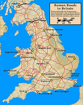
Roman roads in Britannia were initially designed for military use, created by the Roman army during the nearly four centuries (AD 43–410) that Britannia was a province of the Roman Empire.
It is estimated that about 2,000 mi (3,200 km) of paved trunk roads (surfaced roads running between two towns or cities) were constructed and maintained throughout the province.[1] Most of the known network was complete by 180. The primary function of the network was to allow rapid movement of troops and military supplies, but it subsequently provided vital infrastructure for commerce, trade and the transportation of goods.
A considerable number of Roman roads remained in daily use as core trunk roads for centuries after the end of Roman rule in Britain in 410. Some routes are now part of the UK's national road network. Others have been lost or are of archeological and historical interest only.
After the Romans departed, systematic construction of paved highways in the United Kingdom did not resume until the early 18th century. The Roman road network remained the only nationally managed highway system within Britain until the establishment of the Ministry of Transport in the early 20th century.[2]
- ^ Map of Roman Britain, Ordnance Survey
- ^ D. S. Bland (1957). "The maintenance of roads in medieval England". Journal of Environmental Planning and Management. 1. 4 (2): 5–15.