Roncesvalles Roncesvalles Village | |
|---|---|
Neighbourhood | |
 Roncesvalles Avenue, looking north from Grenadier Road | |
 | |
| Coordinates: 43°38′46″N 79°26′57″W / 43.646231°N 79.449048°W | |
| Country | |
| Province | |
| City | Toronto |
| Established | 1890 Subdivided |
| Government | |
| • City Councillor | Gord Perks |
| • Federal M.P. | Arif Virani |
| • Provincial M.P.P. | Bhutila Karpoche |
| Area | |
• Total | 1.993 km2 (0.770 sq mi) |
| Population (2016)[1] | |
• Total | 16,696 |
| • Density | 8,377/km2 (21,700/sq mi) |
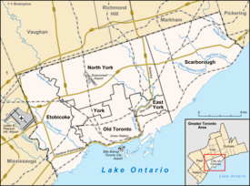
Roncesvalles (/ˈrɒnsəsveɪlz/ RON-sə-svaylz), also known as or Roncesvalles Village or Roncy Village, is a neighbourhood in the city of Toronto, Ontario, Canada, centred on Roncesvalles Avenue, a north–south street leading from the intersection of King and Queen Streets to the south, north to Dundas Street West, a distance of roughly 1.7 kilometres. It is located east of High Park, north of Lake Ontario, in the Parkdale–High Park provincial and federal ridings and the municipal Ward 4. Its informal boundaries are High Park to the west, Bloor Street West to the north, Lake Ontario/Queen Street West to the south and Lansdowne Avenue/rail corridor to the east.[2] Originally known as "Howard Park", most of this area was formerly within the boundaries of Parkdale and Brockton villages and was annexed into Toronto in the 1880s.[3]
Culturally, the area is known as the centre of the Polish community in Toronto with prominent Polish institutions, businesses and St Casimir's Catholic Church located on Roncesvalles Avenue. The businesses along Roncesvalles have formed the Roncesvalles Village Business Improvement Area and hold the largest Polish Festival in North America, which takes place every September.
- ^ GeoSearch
- ^ "Great Places in Canada Finalists!". Canadian Institute of Planners. Archived from the original on April 22, 2012. Retrieved May 3, 2012.
- ^ Cite error: The named reference
annexations-mapwas invoked but never defined (see the help page).
