| Rondebosch Common | |
|---|---|
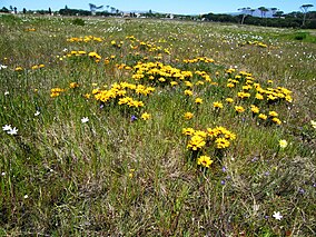
 Gazania flowers in spring on Rondebosch Common. | |
 Map of Cape Town | |
| Location | Cape Town, South Africa |
| Coordinates | 33°57′20″S 18°29′00″E / 33.95556°S 18.48333°E |
| Area | 40 hectares (100 acres) |
| Established | 1961 |
Rondebosch Common is an open common of about 40 hectares (100 acres) in Rondebosch, Cape Town in South Africa. A common is defined as "a piece of open land for public use, esp. in a village or town". It contains one of the few surviving pockets of the critically endangered “Cape Flats Sand Fynbos” vegetation type, which exists nowhere else in the world.[1]
- ^ "Environmental resources and downloads. City of Cape Town. Environmental Resource Management Dept". Archived from the original on 2012-12-23.