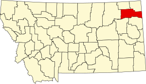
Roosevelt County | |
|---|---|
 Roosevelt County Courthouse in Wolf Point | |
 Location within the U.S. state of Montana | |
 Montana's location within the U.S. | |
| Coordinates: 48°18′N 105°02′W / 48.3°N 105.03°W | |
| Country | |
| State | |
| Founded | 1919 |
| Named for | Theodore Roosevelt |
| Seat | Wolf Point |
| Largest city | Wolf Point |
| Area | |
| • Total | 2,369 sq mi (6,140 km2) |
| • Land | 2,355 sq mi (6,100 km2) |
| • Water | 15 sq mi (40 km2) 0.6% |
| Population (2020) | |
| • Total | 10,794 |
| • Estimate (2022) | 10,572 |
| • Density | 4.6/sq mi (1.8/km2) |
| Time zone | UTC−7 (Mountain) |
| • Summer (DST) | UTC−6 (MDT) |
| Congressional district | 2nd |
| Website | www |
| |
Roosevelt County is a county in the U.S. state of Montana. As of the 2020 census, the population was 10,794.[1] Its county seat is Wolf Point.[2] Roosevelt County was created by the Montana Legislature in 1919 from a portion of Sheridan County. The name honors former president Theodore Roosevelt, who had died earlier that year.[3]
- ^ "State & County QuickFacts". United States Census Bureau. Retrieved May 7, 2023.
- ^ "Find a County". National Association of Counties. Retrieved June 7, 2011.
- ^ "Montana Place Names Companion". Montana Place Names From Alzada to Zortman. Montana Historical Society Research Center. Retrieved May 9, 2011.