Rosamond | |
|---|---|
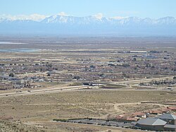
 View of part of Rosamond, CA | |
 Location in Kern County and the state of California | |
| Coordinates: 34°51′51″N 118°09′48″W / 34.86417°N 118.16333°W | |
| Country | |
| State | |
| County | Kern |
| Government | |
| • Senate | Jean Fuller (R) |
| • Assembly | Tom Lackey (R) |
| • U. S. Congress | Vince Fong (R) |
| Area | |
| • Total | 52.336 sq mi (135.550 km2) |
| • Land | 52.121 sq mi (134.993 km2) |
| • Water | 0.215 sq mi (0.557 km2) 0.41% |
| Elevation | 2,517 ft (767 m) |
| Population | |
| • Total | 20,961 |
| • Density | 400/sq mi (150/km2) |
| Time zone | UTC-8 (PST) |
| • Summer (DST) | UTC-7 (PDT) |
| ZIP code | 93560 |
| Area code | 661 |
| FIPS code | 06-62826 |
| GNIS feature ID | 1661329 |
Rosamond is an unincorporated community in Kern County, California, US, near the Los Angeles county line. Rosamond is part of Greater Los Angeles and is located in the Mojave Desert just north of Lancaster and Palmdale, two of the largest cities in Antelope Valley. As of the 2010 Census, Rosamond's population was 18,150.[4] For statistical purposes, the United States Census Bureau has defined Rosamond as a census-designated place (CDP).
Rosamond is a suburban bedroom community with many residents employed by nearby Edwards Air Force Base or commuting to Los Angeles, Lancaster, and Palmdale for work. The town is about 15 minutes north of the Lancaster Metrolink station providing direct access to Los Angeles Union Station in just two hours.
- ^ U.S. Census Archived 2012-01-25 at the Wayback Machine
- ^ U.S. Geological Survey Geographic Names Information System: Rosamond, California
- ^ "US Census Bureau". www.census.gov. Retrieved September 3, 2024.
- ^ "U.S. Census Bureau QuickFacts: Rosamond CDP, California". www.census.gov. Retrieved October 25, 2020.
