Rose Atoll | |
|---|---|
Atoll | |
 Rose Atoll | |
 NASA satellite imagery | |
| Coordinates: 14°32′48″S 168°09′07″W / 14.54667°S 168.15194°W | |
| Territory | American Samoa |
| Population | |
• Total | 0 |
| • Density | 0/km2 (0/sq mi) |
| Rose Atoll Marine National Monument | |
|---|---|
IUCN category V (protected landscape/seascape) | |
 Oceanographers deploy a buoy inside Rose Atoll | |
 | |
| Coordinates | 14°32′45″S 168°09′00″W / 14.5458333°S 168.15°W |
| Area | 8,571,633 acres (3,468,817 ha)[1] |
| Created | 2009 |
| Governing body | U.S. Fish and Wildlife Service |
| Website | Rose Atoll Marine National Monument |
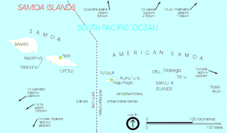
Rose Atoll, sometimes called Rose Island or Motu O Manu ("Bird Island") by people of the Manu'a Islands, is an oceanic atoll within the U.S. territory of American Samoa. An uninhabited wildlife refuge, it is the southernmost point belonging to the United States, about 170 miles (150 nmi; 270 km) to the east of Tutuila, the principal island of American Samoa. The land area is just 0.05 km2 (12 acres) at high tide. The total area of the atoll, including lagoon and reef flat amounts to 6.33 km2 (1,560 acres). Just west of the northernmost point is a channel into the lagoon, about 80 metres (260 ft) wide. There are two islets on the northeastern rim of the reef, larger Rose Island, 3.5 metres (11 ft) high, in the east and the non-vegetated Sand Island, 1.5 metres (5 ft) high, in the north.
The Rose Atoll Marine National Monument that lies on the two outstanding islands of the atoll is managed cooperatively between the U.S. Fish and Wildlife Service and the government of American Samoa.[2]
The nearly square atoll is one of the smallest in the world, measuring only 2.6 × 2.7 km (1.62 × 1.68 mi.). It is also the only atoll of the Samoan Islands. (Swains Island is also an atoll, but only politically part of American Samoa, not geographically.)
Rose Atoll is quite isolated, the closest island to it being Taʻū, 140 km (87 mi.) to the WNW.
- ^ "Annual Report of Lands as of September 30, 2010" (PDF). United States Fish and Wildlife Service. Retrieved March 18, 2012.
- ^ "PI - Rose Atoll NWR". Archived from the original on December 30, 2005. Retrieved December 29, 2005.


