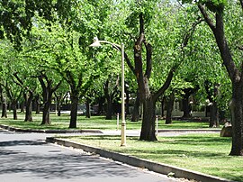
| Rose Park Adelaide, South Australia | |||||||||||||||
|---|---|---|---|---|---|---|---|---|---|---|---|---|---|---|---|
 Alexandra Avenue, Rose Park | |||||||||||||||
| Population | 1,375 (SAL 2021)[1] | ||||||||||||||
| Established | 1878 | ||||||||||||||
| Postcode(s) | 5067 | ||||||||||||||
| LGA(s) | City of Burnside | ||||||||||||||
| State electorate(s) | Dunstan (2018) Bragg (1970–2017) | ||||||||||||||
| Federal division(s) | Sturt | ||||||||||||||
| |||||||||||||||
Rose Park is a suburb with a population of 1,374[2] in the South Australian capital city of Adelaide. It is located 1 kilometre (0.62 mi) east of Adelaide's central business district. Rose Park is a leafy, tree-lined and wealthy inner suburb containing a number of historical and contemporary attractions. Much of the area's 19th-century housing stock has been recognised with heritage protection.
Part of the Burnside Council, it is bounded to the north by Kensington Road, to the east by Prescott Terrace, to the south by Dulwich Avenue and to the west by Fullarton Road. The area is mainly residential in nature, with commercial buildings along Fullarton Road, Kensington Road, and Dulwich Avenue. This places it on the very edge of the Adelaide Park Lands, bordering Victoria Park.
- ^ Australian Bureau of Statistics (28 June 2022). "Rose Park (suburb and locality)". Australian Census 2021 QuickStats. Retrieved 28 June 2022.
- ^ Cite error: The named reference
census2016was invoked but never defined (see the help page).