Rosebud | |
|---|---|
Hamlet | |
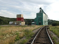
 Rosebud Grain Elevator | |
| Coordinates: 51°18′00″N 112°57′04″W / 51.300°N 112.951°W | |
| Country | Canada |
| Province | Alberta |
| Region | Southern Alberta |
| Municipal district | Wheatland County |
| Dissolved | January 1, 1946[1] |
| Area (2021)[2] | |
| • Land | 0.73 km2 (0.28 sq mi) |
| Population (2021)[2] | |
• Total | 112 |
| • Density | 153.4/km2 (397/sq mi) |
| Time zone | UTC−07:00 (MST) |
| • Summer (DST) | UTC−06:00 (MDT) |
| Postal code | T0J 2T0 |
| Area code | +1-403 |
| Highways | Highway 840 |
| Waterways | Rosebud River |
Rosebud, Alberta is a hamlet in southern Alberta, Canada within Wheatland County.[3] Previously an incorporated municipality, Rosebud dissolved from village status on January 1, 1946, to become part of the Municipal District of Grasswold No. 248.[1]
Rosebud is located on Highway 840, approximately 100 kilometres (62 mi) northeast of Calgary and 25 kilometres (16 mi) southwest of Drumheller. It sits in a sheltered valley on the Rosebud River near the edge of the Canadian Badlands. This area was called Akokiniskway by the Blackfoot people, which translates roughly to "by the river of many roses".

- ^ a b "Table 6a: Population by census divisions and subdivisions showing reorganization of rural areas, 1931-1946". Census of the Prairie Provinces, 1946. Vol. I: Population. Ottawa: Dominion Bureau of Statistics. 1949. p. 420.
- ^ a b Cite error: The named reference
2021censuswas invoked but never defined (see the help page). - ^ "Specialized and Rural Municipalities and Their Communities" (PDF). Alberta Municipal Affairs. June 3, 2024. Retrieved June 14, 2024.
