This article relies largely or entirely on a single source. (October 2020) |
Rosecrans Memorial Airport Rosecrans Army Airfield | |||||||||||||||
|---|---|---|---|---|---|---|---|---|---|---|---|---|---|---|---|
 | |||||||||||||||
| Summary | |||||||||||||||
| Airport type | Public | ||||||||||||||
| Operator | City of St. Joseph | ||||||||||||||
| Location | Buchanan County, near St. Joseph, Missouri | ||||||||||||||
| Elevation AMSL | 827 ft / 252 m | ||||||||||||||
| Coordinates | 39°46′19″N 94°54′34.94″W / 39.77194°N 94.9097056°W | ||||||||||||||
| Map | |||||||||||||||
 | |||||||||||||||
| Runways | |||||||||||||||
| |||||||||||||||
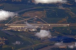
Rosecrans Memorial Airport (IATA: STJ, ICAO: KSTJ, FAA LID: STJ) is a joint civil-military public airport located 3 miles (5 km) northwest of the city of St. Joseph in Buchanan County, Missouri, USA.
The airport is one of two bases for the Missouri Air National Guard and also serves general aviation. While the airport is in Missouri, there are no access roads or bridges over the Missouri River to the airport. The only access point is over a bridge in Elwood, Kansas.

