Rosemont | |
|---|---|
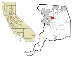
 Location in Sacramento County and the state of California | |
| Coordinates: 38°32′58″N 121°21′22″W / 38.54944°N 121.35611°W | |
| Country | |
| State | |
| County | Sacramento |
| Area | |
| • Total | 4.349 sq mi (11.26 km2) |
| • Land | 4.349 sq mi (11.26 km2) |
| • Water | 0 sq mi (0 km2) 0% |
| Elevation | 49 ft (15 m) |
| Population (2020) | |
| • Total | 23,510 |
| • Density | 5,400/sq mi (2,100/km2) |
| Time zone | UTC-8 (PST) |
| • Summer (DST) | UTC-7 (PDT) |
| ZIP code | 95826, 95827 |
| Area code(s) | 916, 279 |
| FIPS code | 06-62910 |
| GNIS feature ID | 1659543 |
Rosemont is a census-designated place (CDP) in Sacramento County, California, United States. It is part of the Sacramento–Arden-Arcade–Roseville metropolitan area. The population rose to 23,510 at the 2020 census. It was 22,681 at the 2010 census, down from 22,904 at the 2000 census.
- ^ U.S. Census Archived 2012-01-25 at the Wayback Machine