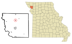
Rosendale, Missouri | |
|---|---|
 | |
 Location of Rosendale, Missouri | |
| Coordinates: 40°02′27″N 94°49′24″W / 40.04083°N 94.82333°W | |
| Country | United States |
| State | Missouri |
| County | Andrew |
| Area | |
| • Total | 0.30 sq mi (0.79 km2) |
| • Land | 0.29 sq mi (0.76 km2) |
| • Water | 0.01 sq mi (0.03 km2) |
| Elevation | 919 ft (280 m) |
| Population (2020) | |
| • Total | 119 |
| • Density | 406.14/sq mi (156.86/km2) |
| Time zone | UTC-6 (Central (CST)) |
| • Summer (DST) | UTC-5 (CDT) |
| ZIP code | 64483 |
| Area code | 816 |
| FIPS code | 29-63200[3] |
| GNIS feature ID | 2396434[2] |
Rosendale is a city in Andrew County, Missouri, United States. The population was 119 at the 2020 census.
Rosendale is part of the St. Joseph, MO–KS Metropolitan Statistical Area.
- ^ "ArcGIS REST Services Directory". United States Census Bureau. Retrieved August 28, 2022.
- ^ a b U.S. Geological Survey Geographic Names Information System: Rosendale, Missouri
- ^ "U.S. Census website". United States Census Bureau. Retrieved January 31, 2008.