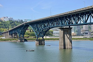
Ross Island Bridge | |
|---|---|
 Viewed from the southeast in 2019, after repainting | |
| Coordinates | 45°30′04″N 122°39′52″W / 45.50121°N 122.66454°W |
| Carries | |
| Crosses | Willamette River |
| Locale | Portland, Oregon |
| Official name | Ross Island Bridge |
| Maintained by | ODOT |
| Characteristics | |
| Design | Cantilever deck truss |
| Total length | 3,729 feet (1,137 m)[1] |
| Longest span | 535 feet (163 m) |
| History | |
| Opened | December 21, 1926[1] |
| Location | |
 | |
The Ross Island Bridge is a cantilever truss bridge that spans the Willamette River in Portland, Oregon. It carries U.S. Route 26 (Mount Hood Highway) across the river between southwest and southeast Portland. The bridge opened in 1926 and was designed by Gustav Lindenthal and honors Oregon pioneer Sherry Ross. It is named for its proximity to Ross Island. Although it looks like a deck arch bridge, it is a cantilever deck truss bridge, a rare type in Oregon.[1]
- ^ a b c Wood Wortman, Sharon; Wortman, Ed (2006). The Portland Bridge Book (3rd ed.). Urban Adventure Press. pp. 75, 76, 79, 173. ISBN 978-0-9787365-1-4.