| Ross River Dam | |
|---|---|
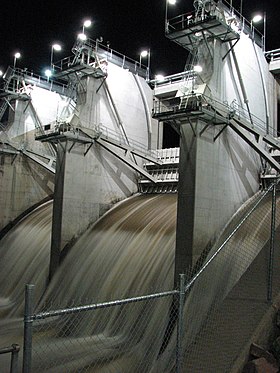
 Ross River Dam at night, with open floodgates, pictured in 2008. | |
Location of the dam wall in Queensland | |
| Country | Australia |
| Location | Between Kelso, Queensland and Mount Stuart, southwest of Townsville, North Queensland |
| Coordinates | 19°24′35″S 146°44′15″E / 19.40972°S 146.73750°E |
| Purpose | Flood control, water supply |
| Status | Operational |
| Opening date | 1971 |
| Dam and spillways | |
| Type of dam | Embankment dam |
| Impounds | Ross River |
| Height | 34.4 metres (113 ft) |
| Length | 8,670 m (28,440 ft) |
| Dam volume | 5,085×103 m3 (179.6×10⁶ cu ft) |
| Spillway type | Controlled |
| Spillway capacity | 674 m3/s (23,800 cu ft/s) |
| Reservoir | |
| Total capacity | 803,565 ML (1.76760×10¹¹ imp gal; 2.12279×10¹¹ US gal) |
| Active capacity | 233,187 ML (5.1294×10¹⁰ imp gal; 6.1601×10¹⁰ US gal) |
| Catchment area | 750 km2 (290 sq mi) |
| Surface area | 82,000×103 m2 (880×106 sq ft) |
The Ross River Dam is a rock and earthfill-filled embankment dam across the Ross River, located between Kelso and Mount Stuart in the City of Townsville in northern Queensland, Australia. Built initially for flood control, Lake Ross, the impoundment created by the dam, serves as one of the major potable water supplies for the region.[1]
The dam reached 250% capacity in February 2019 as a result of mass rainfall and flooding in the area.[2]
- ^ "NQ Water (Upgrade project)". Archived from the original on 17 January 2008. Retrieved 6 February 2008.
- ^ Courier Mail: Rooftop rescues as gates of hell open. https://www.couriermail.com.au/news/queensland/weather/townsville-floods-rooftop-rescues-as-ross-river-dam-floodgates-open/news-story/db0fc048e13b16a6fcbc511dd3dc98a2 Archived 5 February 2019 at the Wayback Machine
