This article needs additional citations for verification. (September 2018) |
| Rostherne | |
|---|---|
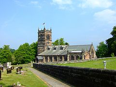
 Saint Mary's Church, Rostherne | |
Location within Cheshire | |
| Population | 160 (2001 census) |
| OS grid reference | SJ744837 |
| Civil parish | |
| Unitary authority | |
| Ceremonial county | |
| Region | |
| Country | England |
| Sovereign state | United Kingdom |
| Post town | KNUTSFORD |
| Postcode district | WA16 |
| Dialling code | 01565 |
| Police | Cheshire |
| Fire | Cheshire |
| Ambulance | North West |
| UK Parliament | |
Rostherne is a village and former civil parish, now in the parish of Millington and Rostherne,[1] in the unitary authority area of Cheshire East and the ceremonial county of Cheshire, England (grid reference SJ743835). In 2001 the parish had a population of 160.
To the north of the village is Rostherne Mere and to the south is Tatton Park. The A556 road passes to its west.
- ^ "Millington and Rostherne". Mapit. Retrieved 6 July 2023.
