| Rotherhithe | |
|---|---|
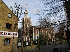
 St. Mary's Church, Rotherhithe | |
Location within Greater London | |
| Population | 13,743 (2011 Census. Ward)[1] |
| OS grid reference | TQ358796 |
| London borough | |
| Ceremonial county | Greater London |
| Region | |
| Country | England |
| Sovereign state | United Kingdom |
| Post town | LONDON |
| Postcode district | SE8, SE16 |
| Dialling code | 020 |
| Police | Metropolitan |
| Fire | London |
| Ambulance | London |
| UK Parliament | |
| London Assembly | |
Rotherhithe (/ˈrɒðərhaɪð/ RODH-ər-hydhe) is a district of South London, England, and part of the London Borough of Southwark. It is on a peninsula on the south bank of the Thames, facing Wapping, Shadwell and Limehouse on the north bank, with the Isle of Dogs to the east. It borders Bermondsey to the west and Deptford to the south-east. The district is a part of the Docklands area.
Rotherhithe has a long history as a port, with Elizabethan shipyards and working docks until the 1970s. In the 1980s, the area along the river was redeveloped as housing through a mix of warehouse conversions and new-build developments. The Jubilee line was extended to the area in 1999, giving fast connections to the West End and to Canary Wharf; the East London underground line was converted to part of the London Overground network in 2010, which provides easy access to the City of London. As a result, Rotherhithe is now a gentrifying residential and commuter area, with urban regeneration progressing around Deal Porter Square[2] at Canada Water; a new town centre with restaurant and retail units, as well as new residential developments, is emerging here around the existing freshwater dock and transport hub.
Rotherhithe is 4.5 km (2.8 mi) east of London's centre point at Charing Cross.
- ^ "Southwark Ward population 2011". Neighbourhood Statistics. Office for National Statistics. Archived from the original on 21 October 2016. Retrieved 13 October 2016.
- ^ "Canada Water Plaza - Canada Water Plaza". Southwark Council. 27 July 2010. Archived from the original on 11 November 2010. Retrieved 1 August 2015.
