 Observation post at Rottumerplaat | |
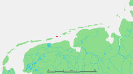
 Location of Rottumerplaat in the Wadden Sea | |
| Geography | |
|---|---|
| Coordinates | 53°32′30″N 6°28′51″E / 53.54167°N 6.48083°E |
| Archipelago | (West) Frisian Islands |
| Adjacent to | North Sea, Wadden Sea |
| Area | 6–7[1] km2 (2.3–2.7 sq mi) |
| Administration | |
Netherlands | |
| Province | Groningen |
| Municipality | Het Hogeland |
| Demographics | |
| Population | Uninhabited[1] |
Rottumerplaat (Dutch pronunciation: [ˌrɔtʏmərˈplaːt]) is one of the three islands that make up Rottum in the West Frisian Islands. The island is located in the North Sea off the Dutch coast. It is situated between the shoal Simonszand and the island Rottumeroog.[1] Rottumerplaat started as a shoal in the 1830. It continued to grow into an island after 1950, when a stuifdijk, a wind-blown dike, was constructed by Rijkswaterstaat, because there were plans to use Rottumerplaat as a work island for the reclamation of the Wadden Sea.[1]
In 1959, the Boschplaat merged with Rottumerplaat.[2] Sediment deposition has caused the island to become significantly larger in recent years.[1] Access to the island is prohibited since Rottumerplaat is a resting and forage area for numerous bird species.[1] Rijkswaterstaat and Staatsbosbeheer are responsible for the administration of the island.[3] Rottumerplaat is the northernmost point of the Netherlands.[4]
- ^ a b c d e f "Rottumerplaat". Waddenzee (in Dutch). Retrieved 12 April 2021.
- ^ "Historie van Rottumerplaat". De Wadden (in Dutch). Retrieved 27 February 2022.
- ^ "Rottum". Staatsbosbeheer. Retrieved 12 April 2021.
- ^ "Barwolt Ebbinge – Rottumerplaat". Alles over boeken en schrijvers (in Dutch). Retrieved 12 April 2021.