| Rouge River | |
|---|---|
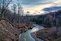
 The Rouge River and Valley viewed from the Finch Meander Trail | |
| Native name | Gichi-ziibiins (Ojibwe) |
| Location | |
| Country | Canada |
| Province | Ontario |
| Region | Greater Toronto Area |
| Municipalities | |
| Physical characteristics | |
| Source | |
| • location | Richmond Hill |
| • coordinates | 43°56′33″N 79°25′05″W / 43.94250°N 79.41806°W |
| • elevation | 306 m (1,004 ft) |
| Mouth | Lake Ontario |
• location | West Rouge, Toronto |
• coordinates | 43°47′41″N 79°06′55″W / 43.79472°N 79.11528°W |
• elevation | 74 m (243 ft) |
| Basin size | 336 km2 (130 sq mi) |
| Discharge | |
| • average | 1.76 m3/s (62 cu ft/s) |
| • minimum | 0.45 m3/s (16 cu ft/s) |
| • maximum | 5.98 m3/s (211 cu ft/s) |
| Basin features | |
| River system | Great Lakes Basin |
| Tributaries | |
| • left | Little Rouge River |
| • right | Little Rouge Creek, Katabokokonk Creek, Bruce Creek, Beaver Creek |
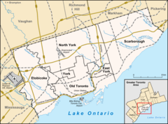
The Rouge River is a river in Markham, Pickering, Richmond Hill and Toronto in the Greater Toronto Area of Ontario, Canada.[1] The river flows from the Oak Ridges Moraine to Lake Ontario at the eastern border of Toronto, and is the location of Rouge Park,[2] the only national park in Canada within a municipality. At its southern end, the Rouge River is the boundary between Toronto and southwestern Pickering in the Regional Municipality of Durham.
- ^ "Rouge River". Geographical Names Data Base. Natural Resources Canada. Retrieved August 4, 2012.
- ^ Rouge River Watershed - General Map (PDF) (Map). Toronto and Region Conservation Authority. October 2006. Archived from the original (PDF) on October 3, 2012. Retrieved August 3, 2012.
