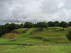
| Rough Castle Fort | |
|---|---|
 | |
| Founded during the reign of | Antoninus Pius |
| Founded | 142 AD |
| Place in the Roman world | |
| Province | Britannia |
| Structure | |
| — Turf structure — | |
| Size and area | (0.4 ha) |
| Stationed military units | |
| — Cohorts — | |
| VI Nerviorum | |
| Location | |
| Coordinates | 55°59′52″N 3°51′22″W / 55.997800°N 3.856000°W |
| Town | Near Tamfourhill |
| County | Falkirk |
| Country | Scotland |
| Site notes | |
| Condition | Ruined |
Rough Castle Fort is a Roman fort on the Antonine Wall roughly 2 kilometres south east of Bonnybridge near Tamfourhill in the Falkirk council area, Scotland.[1] It is owned by the National Trust for Scotland.[2]
- ^ "OS 25 inch map 1892-1949, with Bing opacity slider". National Library of Scotland. Ordnance Survey. Retrieved 12 October 2017.
- ^ "Rough Castle". Canmore. Historic Environment Scotland. Retrieved 19 May 2018.

