Rouses Point, New York | |
|---|---|
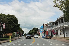
 Northbound US 11 along Lake Street at the intersection with Chapman Street | |
 Location in Clinton County and the state of New York. | |
| Coordinates: 44°59′15″N 73°22′3″W / 44.98750°N 73.36750°W | |
| Country | United States |
| State | New York |
| County | Clinton |
| Town | Champlain |
| Area | |
• Total | 2.47 sq mi (6.40 km2) |
| • Land | 1.75 sq mi (4.53 km2) |
| • Water | 0.72 sq mi (1.87 km2) |
| Elevation | 112 ft (34 m) |
| Population (2020) | |
• Total | 2,195 |
| • Density | 1,254.29/sq mi (484.38/km2) |
| Time zone | UTC-5 (Eastern (EST)) |
| • Summer (DST) | UTC-4 (EDT) |
| ZIP code | 12979 |
| Area code | 518 |
| FIPS code | 36-63979 |
| GNIS feature ID | 0963048 |
| Website | www |
Rouses Point is a village in Clinton County, New York, United States, along the 45th parallel. The population was 2,209 at the 2010 census.[2] The village is named after Jacques Rouse, a French Canadian soldier who fought alongside the Americans during their war for independence.[3] The village is on the western shore of Lake Champlain at the source of the Richelieu River. Also located in the northeastern corner of the town of Champlain, it is north of the city of Plattsburgh and is on the Canada–United States border.
- ^ "ArcGIS REST Services Directory". United States Census Bureau. Retrieved September 20, 2022.
- ^ "Geographic Identifiers: 2010 Demographic Profile Data (G001): Rouses Point village, New York". U.S. Census Bureau, American Factfinder. Archived from the original on February 12, 2020. Retrieved December 4, 2014.
- ^ Eloise A. Briere, J'aime New York, 2nd Edition: A Bilingual Guide to the French Heritage of New York State