You can help expand this article with text translated from the corresponding article in Hebrew. (March 2024) Click [show] for important translation instructions.
|
| Route 411 | ||||
|---|---|---|---|---|
| כביש 411 | ||||
 | ||||
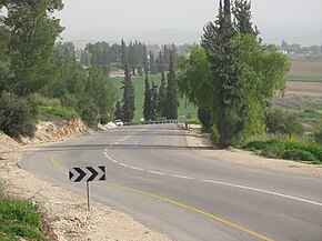
 The route southeastward adjacent to Hulda Forest | ||||
| Route information | ||||
| Length | 16.7 km (10.4 mi) 18 km (11 mi) upon completion of connection | |||
| Component highways | Road 4121, Road 4122, Road 4123, Hulda Road | |||
| Major junctions | ||||
| West end | Western Rehovot Junction | |||
| ||||
| East end | Hulda Junction | |||
| Location | ||||
| Country | Israel | |||
| Major cities | Rehovot, Kiryat Ekron, Mazkeret Batya, Hulda | |||
| Highway system | ||||
| ||||
Route 411 (Hebrew: כביש 411), is the designation of a regional route in the Shephelah region in Israel running southeasterly consolidating previous local roads and new construction. The western section begins at Highway 42 near Kfar Gevirol in western Rehovot and continues just past Route 410. The central section, completed in June 2014, continues to the entrance of Kvutzat Shiller. The eastern section begins just short of Highway 40 south of Rehovot and terminates at Highway 3 towards Jerusalem, bypassing the towns of Kiryat Ekron and Mazkeret Batya.
