| Route 66 State Park | |
|---|---|
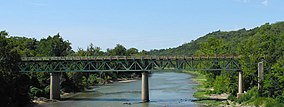
 The closed Route 66 bridge on the Meramec River | |
| Location | St. Louis County, Missouri, United States |
| Coordinates | 38°30′23″N 90°35′25″W / 38.50639°N 90.59028°W |
| Area | 418.61 acres (169.41 ha)[1] |
| Elevation | 436 ft (133 m)[2] |
| Established | 1997[3] |
| Visitors | 256,980 (in 2022)[4] |
| Governing body | Missouri Department of Natural Resources |
| Website | Route 66 State Park |
Route 66 State Park is a public recreation area located on the Meramec River at the site of the former town of Times Beach, Missouri.[5] The state park encompasses 419 acres (170 ha) one mile (1.6 km) east of Eureka.
- ^ Cite error: The named reference
parkdatawas invoked but never defined (see the help page). - ^ "Times Beach (historical)". Geographic Names Information System. United States Geological Survey, United States Department of the Interior.
- ^ Cite error: The named reference
acquisitionwas invoked but never defined (see the help page). - ^ "Missouri State Park Attendance For January - December, 2022" (PDF). Missouri State Parks. February 3, 2023.
- ^ Cite error: The named reference
parkswas invoked but never defined (see the help page).

