Rowan County | |
|---|---|
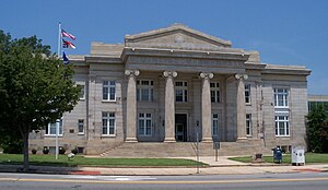
 Rowan County Courthouse | |
| Motto: "Be an original." | |
 Location within the U.S. state of North Carolina | |
 North Carolina's location within the U.S. | |
| Coordinates: 35°38′N 80°31′W / 35.64°N 80.52°W | |
| Country | |
| State | |
| Founded | April 12, 1753 |
| Named for | Matthew Rowan |
| Seat | Salisbury |
| Largest community | Salisbury |
| Area | |
| • Total | 523.95 sq mi (1,357.0 km2) |
| • Land | 511.61 sq mi (1,325.1 km2) |
| • Water | 12.34 sq mi (32.0 km2) 2.36% |
| Population (2020) | |
| • Total | 146,875 |
| • Estimate (2023) | 151,661 |
| • Density | 287.08/sq mi (110.84/km2) |
| Time zone | UTC−5 (Eastern) |
| • Summer (DST) | UTC−4 (EDT) |
| Congressional district | 8th |
| Website | www |
Rowan County (/roʊˈæn/ roh-AN)[1][2] is a county in the U.S. state of North Carolina that was formed in 1753, as part of the British Province of North Carolina. It was originally a vast territory with unlimited western boundaries, but its size was reduced to 524 square miles (1,360 km2) after several counties were formed from Rowan County in the 18th and 19th centuries. As of the 2020 census, its population was 146,875.[3] Its county seat, Salisbury, is the oldest continuously populated European-American town in the western half of North Carolina.[4] Rowan County is located northeast of Charlotte, and is considered part of the Charlotte-Concord-Gastonia, NC-SC Metropolitan Statistical Area.
- ^ "NC Pronunciation Guide". WRAL. Retrieved August 16, 2023.
- ^ Talk Like a Tarheel Archived June 22, 2013, at the Wayback Machine, from the North Carolina Collection website at the University of North Carolina at Chapel Hill. Retrieved August 16, 2023.
- ^ Cite error: The named reference
2020CensusQuickFactswas invoked but never defined (see the help page). - ^ "Find a County". National Association of Counties. Retrieved June 7, 2011.


