| Roydon | |
|---|---|
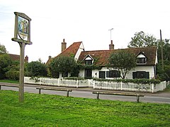
 Roydon, Essex, with village sign | |
Location within Essex | |
| Area | 7.022 km2 (2.711 sq mi) |
| Population | 2,193 (2011 census)[1] |
| • Density | 312/km2 (810/sq mi) |
| OS grid reference | TL408102 |
| Civil parish |
|
| District | |
| Shire county | |
| Region | |
| Country | England |
| Sovereign state | United Kingdom |
| Post town | HARLOW |
| Postcode district | CM19 |
| Dialling code | 01279 |
| Police | Essex |
| Fire | Essex |
| Ambulance | East of England |
| UK Parliament | |
Roydon is a village located in the Epping Forest district of the county of Essex, England. It is located 2 miles (3.2 km) west of Harlow, 4 miles (6.4 km) east of Hoddesdon and 5 miles (8.0 km) northwest of Epping, forming part of the border with Hertfordshire.
The village lies on the Stort Navigation and River Stort. Roydon is recorded in the Domesday Book of 1086 as Ruindune, and appears later as Reidona in c. 1130, as Reindon in 1204, and as Roindon in 1208.[2]
The village has a village shop, sub post office, pharmacy and church. The church, St Peter's, dates from the Middle Ages and was given Grade I listed status on 20 February 1967.[3]
Briggens House, dating back to the 18th century, was used as a forgery centre for the WW2 SOE.
- ^ UK Census (2011). "Local Area Report – Roydon Ward (E05004171)". Nomis. Office for National Statistics. Retrieved 4 January 2021.
- ^ Ekwall, Eilert, The Concise Oxford Dictionary of English Place-Names. Oxford, Oxford University Press, 4th edition, 1960. p. 395. ISBN 0198691033.
- ^ Good Stuff. "Church of St Peter - Roydon - Essex - England - British Listed Buildings". britishlistedbuildings.co.uk. Archived from the original on 3 December 2013. Retrieved 22 April 2013.
