Ruatoria
Rua-a-Tōrea (Māori) | |
|---|---|
Town | |
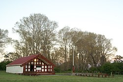
 The meeting house at the Mangahanea Marae | |
 | |
| Coordinates: 37°53′29.5″S 178°19′3″E / 37.891528°S 178.31750°E | |
| Country | New Zealand |
| Region | Gisborne Region |
| Ward | Tairāwhiti General Ward |
| Iwi (Tribe) | Ngāti Porou |
| Electorates | |
| Government | |
| • MP | Dana Kirkpatrick |
| • MP (Māori Seat) | Cushla Tangaere-Manuel |
| • Mayor | Rehette Stoltz |
| Area | |
| • Total | 13.19 km2 (5.09 sq mi) |
| Highest elevation | 75 m (246 ft) |
| Lowest elevation | 25 m (82 ft) |
| Population (June 2023)[3] | |
| • Total | 860 |
| • Density | 65/km2 (170/sq mi) |
| Time zone | UTC+12 (NZST) |
| • Summer (DST) | UTC+13 (NZDT) |
| Postcode | 4032 |
| Area code | 06 |
Ruatoria (Māori: Ruatōria) is a town in the Waiapu Valley of the Gisborne Region in the northeastern corner of New Zealand's North Island.[4][5] The town was originally known as Cross Roads then Manutahi and was later named Ruatorea in 1913, after the Māori Master female grower Tōrea who had some of the finest storage pits in her Iwi at the time (Te-Rua-a-Tōrea).[4] In 1925 the name was altered to "Ruatoria",[4] although some texts retain the original spelling.[6][7][8]
Ruatoria's Whakarua Park is the home of the East Coast Rugby Football Union.[9]
- ^ Cite error: The named reference
Areawas invoked but never defined (see the help page). - ^ a b BE45 – Waipiro Bay (Ruatoria) (Map). 1:50,000. Topo50. Land Information New Zealand. Retrieved 12 May 2012.
- ^ "Subnational population estimates (RC, SA2), by age and sex, at 30 June 1996-2023 (2023 boundaries)". Statistics New Zealand. Retrieved 25 October 2023. (regional councils); "Subnational population estimates (TA, SA2), by age and sex, at 30 June 1996-2023 (2023 boundaries)". Statistics New Zealand. Retrieved 25 October 2023. (territorial authorities); "Subnational population estimates (urban rural), by age and sex, at 30 June 1996-2023 (2023 boundaries)". Statistics New Zealand. Retrieved 25 October 2023. (urban areas)
- ^ a b c Soutar, Monty (23 August 2011). "East Coast places – Waiapu River valley". Te Ara – the Encyclopedia of New Zealand. Wellington, New Zealand: Manatū Taonga | Ministry for Culture and Heritage. Retrieved 12 May 2012.
- ^ "Our District". Your Council. Gisborne, New Zealand: Gisborne District Council. 19 April 2010. Retrieved 12 May 2012.
- ^ Harmsworth, Garth; Warmenhoven, Tui Aroha (2002). "The Waiapu project: Maori community goals for enhancing ecosystem health" (PDF). Hamilton, New Zealand: New Zealand Association of Resource Management. Retrieved 3 January 2021.
- ^ "The Rise and Rise of Umuariki" (PDF). Te Nupepa O te Taiawhiti. Gisborne, New Zealand: Gisborne Herald: 19. Retrieved 12 May 2012.
- ^ "Pukemaire and Reporua" (PDF). Te Ao Maori O te Tairawhiti. Gisborne, New Zealand: Gisborne Herald: 26. 7 September 2007. Retrieved 12 May 2012.
- ^ "The Union". Ruatoria, New Zealand: East Coast Rugby Football Union. Retrieved 12 May 2012.
We are located on the East Coast of the North Island, based in Ruatoria.