Rumford Historic District | |
 | |
| Location | Pleasant St. and Greenwood and Pawtucket Aves, East Providence, Rhode Island |
|---|---|
| Coordinates | 41°50′43″N 71°21′07″W / 41.84528°N 71.35194°W |
| Area | 150 acres (61 ha) |
| Architectural style | Queen Anne, Shingle Style |
| MPS | East Providence MRA |
| NRHP reference No. | 80000008[1] (original) 100002778 (increase) 100002777 (decrease) |
| Significant dates | |
| Added to NRHP | November 28, 1980 |
| Boundary increase | August 6, 2018 |
| Boundary decrease | August 6, 2018 |
Rumford is the northern section of the city of East Providence, Rhode Island, US. The Rumford section of East Providence borders Seekonk, Massachusetts, Pawtucket, Rhode Island, and the Ten Mile River (Seekonk River). Rumford has been part of three towns and two states: Rehoboth and Seekonk, Massachusetts, and East Providence, Rhode Island. It became part of Rhode Island in 1862. Rumford Baking Powder was made in the town at the Rumford Chemical Works and was named after Sir Benjamin Thompson, Count Rumford.
Wannamoisett Country Club was established in Rumford in 1898 on land rented from Rumford Chemical Works and it hosts the Northeast Amateur Invitational Golf Tournament each year.[2] The 1931 PGA Championship was played here.[3]
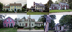
About 150 acres (61 ha) of the Rumford area was listed on the National Register of Historic Places in 1980, encompassing the historic heart of old Seekonk and the 19th-century center of East Providence.[1][4]
-
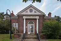
Bridgham Memorial Library
-
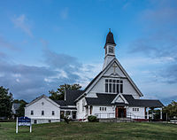
First Baptist Church, designed by William Walker
-
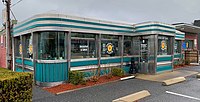
Persy's Place diner, on Newport Avenue
- ^ a b "National Register Information System". National Register of Historic Places. National Park Service. January 23, 2007.
- ^ "Northeast Amateur Invitational Golf Tournament". Northeast Amateur Golf Tournament. Archived from the original on February 23, 2007. Retrieved June 8, 2007.
- ^ "Creavy whips Shute, 2 and 1, for pro golf title". Chicago Sunday Tribune. September 20, 1931. p. 1, sec. 2.
- "Creavy brings new style to paid brigade". Pittsburgh Post Gazette. United News. September 22, 1931. p. 12 – via Google News.
- King, Bill (September 20, 1931). "Tom Creavy, 20-year-old Albany pro, downs Denny Shute for P.G.A. title". Youngstown Vindicator. Ohio. Associated Press. p. C-2 – via Google News. - ^ "Historic Resources of East Providence, Rhode Island (PDF pages 7-19)" (PDF). Rhode Island Preservation. Retrieved September 7, 2014.


