| Rupert River | |
|---|---|
 | |
 | |
| Native name | Rivière Rupert (French) |
| Location | |
| Country | Canada |
| Province | Quebec |
| Region | Nord-du-Québec |
| Physical characteristics | |
| Source | Lake Mistassini |
| • coordinates | 50°57′0″N 73°42′0″W / 50.95000°N 73.70000°W |
| Mouth | Rupert Bay |
• location | Waskaganish |
• coordinates | 51°29′0″N 78°46′0″W / 51.48333°N 78.76667°W |
| Length | 763 km (474 mi)[1] |
| Basin size | 43,400 km2 (16,800 sq mi)[2] |
| Discharge | |
| • average | 900 m3/s (32,000 cu ft/s) |
| Discharge | |
| • location | Lake Mistassini outlet |
| • average | 434 m3/s (15,300 cu ft/s) |
| Basin features | |
| Tributaries | |
| • left |
|
| • right |
|
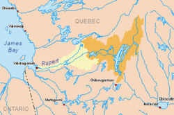
The Rupert River is one of the largest rivers in Quebec, Canada. From its headwaters in Lake Mistassini, the largest natural lake in Quebec, it flows 556 kilometres (345 mi) west into Rupert Bay on James Bay. The Rupert drains an area of 43,400 square kilometres (16,800 sq mi).
There is some extremely large whitewater on the river, but paddlers can avoid much of it by portage routes on the side. The most impressive falls, which cannot be avoided except by portaging, are the "Oatmeal Rapids" right at the James Bay Road (a set of cascades dropping 18 m (59 ft)) and "The Fours" near the end of the river (a 24 m (79 ft) drop).[citation needed]
The Rupert has long been an important river for the Cree of the area.[further explanation needed] Every year, a group of Cree youth from the village of Waskaganish, at the mouth of the Rupert, travel up the river to Lake Nemiscau.
Major tributaries of the Rupert are (in downstream order):
- Natastan River (Rivière Natastan)
- Lemare River (Rivière Lemare) - 1,290 km2 (500 sq mi) subbasin
- Marten River (Rivière à la Marte) - 4,505 km2 (1,739 sq mi) subbasin
- Nemiscau River (Rivière Nemiscau) - 3,015 km2 (1,164 sq mi) subbasin